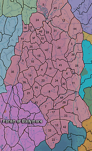
The parish of Ballymore is in the county of Armagh. The following townlands are in this parish:
The parish was described in 1838 in the Ordnance Survey Memoirs:
"Locality
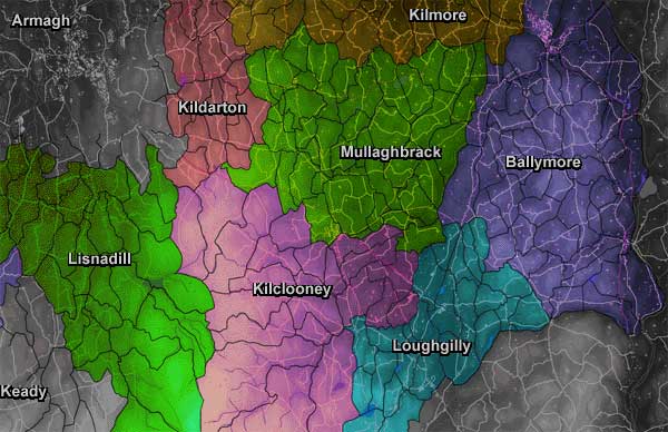
"The parish of Ballymore is situated in the county of Armagh, on the eastern side in the barony of Lower Orior, bounded to the north and north west by the parish of Kilmore, to the south west by the parish of Loughgilly and to the south by the parish of Killevy and to the east by the county of Down, its extreme length from north to south being 9 miles and extreme breadth from east to west 4 and a half miles, its superficial content being 14, 158 acres 3 roods 32 perches, of which 49 acres and 29 perches are water.
"Lakes
"The parish contains no lakes of any considerable magnitude. The following are contained in it: nearly the western half of Lough Shark, situated half a mile to the eastward of the village of Acton, its remaining or eastern portion being in the county of Down. It is elevated to the height of 80 feet above the level of the sea and its dimensions are as follows: extreme length from north north east to south south west half a mile, and extreme breadth from east south east to west north west a third of a mile. Also Lough Moss or Scarva lough, situated in the townland of Aughlish, 2 miles to the south east of Tanderagee at the height of 63 feet above the sea; extreme length from north to south 285 yards, extreme breadth from east to west 132 yards. McCourt's lough, situated 1 mile south west of the village of Poyntzpass, extreme length from north east to south west 374 yards, extreme breadth south east to north west 242 yards. Also a lake situated 2 miles west of the village of Acton, in the townlands of Corlust and Ballyargan and Crewbeg, elevated 258 feet above the level of the sea, extreme length from north to south 418 yards, extreme breadth from east to west 285 yards...
"The towns contained in the parish are Tanderagee, Poyntzpass and Acton...
"Memoir by Lieut G.A. Bennett, June 1835...
" Name and Derivation
"Ballymore [2 short stresses and 1 1ong stress over syllables] or "the large town" is said to take its derivation from the town of Tanderagee, situated in the north end of the parish.
"Locality and Extent
" It is situated in the east side of the county and in the barony of Lower Orier and is bounded on the north by Kilmore, east by Tullylish, Aghaderg and Donoughmore, west by Kilmore, Mullaghbrack and Loughgilly and south by Killevy. Its greatest length is 9 English miles from its extreme southern point in Cullentrough townland joining Killevy parish, to its most northern point in Ballymore joining Kilmore parish. Its greatest breadth is 4 and a quarter miles from east to west. It contains [blank] acres and is divided into 48 townlands. Of these 65 and a half are water, 100 spent bog, 121 marsh and 403 of wood, besides about the half of Derryallen townland containing Lord Mandeville's demesne, and half of Skigatallagh containing part of Colonel Close's demesne, both of which are thickly wooded...
"Hills
"The surface of this parish is broken up into a large number of hills which do not exceed in height above the sea 522 feet. The lowest ground is about the canal along the west side of the parish, only 53 feet. The highest is in the south end of the parish in the townlands of Cullintrough, Carrickbrack, Skigatallagh. Carrickbrack Fort is 522 feet above the sea, a hill in Cullintrough 518 feet, one in Shigatallagh 449 feet. The ground there falls off to the east and west and to the north. In the townland of Tullynacross it is only 175 feet but rises again to 464 feet at Lisseraw Fort. Babylon hill in Mullaghglass townland is 452 feet and commands an extensive view. Glebe hill in Drumnally is 399 feet and a hill in Ballyshielmore is 401 feet. From Glebe hill the ground falls towards the canal on the north east to 53 feet.
" Lakes
" In the north end of Aughlish townland there is a small lake called Scarvagh lough, 64 feet above the sea. It contains about 7 acres. Another in the north end of Demone at its junction with Aughantaraghan and Federnagh contains about 11 acres. Another in the north west side of Crubeg at its junction with Ballyargin and Curlusk contains about 14 and a half acres. Lough Shark, partly in this county and partly in the county of Down, is 80 feet above the sea and is the summit level of the Newry Canal. 33 acres of the lake are in this parish and county.
"Rivers
"The principal river in this parish is the Cusher river, which enters the parish at its most western point in the townland of Maymacullen and becomes the parish boundary in the west for little more than a mile. It then takes a direction through the parish, being the boundary for various t[ow]nlands, for about 6 miles. It is very crooked but its general bearing is north east. Its height above the sea on entering the parish is 175 feet and on leaving it 53 feet. It varies in breadth, the average, perhaps, is 40 feet and depth 1 to 7 feet. Between the townlands of Clare, Moodge [Moodoge] and Druminure and between Cargans and Tullyhue its banks are thickly wooded. It is well adapted for mills, of which there are the following: in the townland of Clare a corn mill with kiln adjoining and a flax mill; in Ballyshielbeg a flax mill; in Druminure a corn mill; in Moodoge a corn and flax mill; in Mullinteer a spade foundry; in Derryallen a flax mill and in Tullyhue a corn and flour mill. These mills are idle about 2 months in the year from the scarcity of water. It is subject to floods in winter when the low grounds through which it runs become flooded. The water of this river likewise supplies the Newry Canal by means of a feeder, an artificial cut commencing at the most eastern bridge near Tanderagee on the north side of the river. It runs through the centre of Cargans townland and enters Terryhoogan, where it crosses the ravine by means of an aquaduct 237 feet in length, supported on 12 arches about 20 foot rise. It enters the canal at the Wash bridge, its whole length being about 3 miles. The other small streams in the parish are not worth noticing in detail.
"Bogs
"There are about 100 acres of spent or worn out bog in this parish, but very little fuel is obtained from it. It is in small places scattered here and there through the parish.
"Woods
"There are no natural woods in this parish. It, however, contains about 403 acres of forest trees, of which 95 acres are in Derryallen, 75 in Skigatallagh,16 in Demone,50 in Brannock, 40 in Clare, 25 in Cargans, 20 in Druminaleg, 14 in Tullyhue, 12 in Moodoge and 12 in Druminure.
"Geology
"The soil is only tolerable in this parish as the clay is too much mixed with sand or gravel. Greywacke projects in many places and seems to be only substratum. " (Ordnance Survey Memoirs, 1835-38)