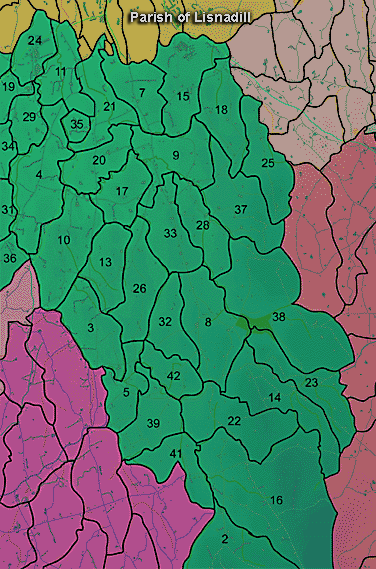
The townland of Ballyards is in the parish of Lisnadill in Armagh County. It is labelled number 4 on the map. H858410
The Environment and Heritage Service Sites and Monuments Record (2002) notes the following in this townland:
Prehistoric BARROW & tree ring? of the Eighteenth Century/Nineteenth Century
SMR NO: ARM 016:006
Irish Grid Reference: H86124152
Townland: BALLYARDS
CONDITION: substantial remains
The site, on top of a low drumlin, consists of a low, circular, grassy mound, 22.5m in diam. & c.1.2m high, and may be the remains of a round barrow. A large stone, perhaps a glacial erratic, 1.14m x 0.85m x 0.4m lies on the NW edge of the mound. The OS 6" map of 1835 shows a "Fort" in this location but this refers to a roughly circular ditch enclosure, 48.5m N-S x 42m E-W which surrounds the mound. This appears to be a recent landscaping feature and both enclosure & mound have been planted with beech & pine trees.
LARGE BIVALLATE enclosure of uncertain period
SMR NO: ARM 016:007
Irish Grid Reference: H86474136
Townland: BALLYARDS
CONDITION: substantial remains
On a slight promontory on the NW side of Butter Water. Although overgrown with dense vegetation, the site remains impressive. The oval interior is 61.5m NE-SW x 37.5 NW-SE & is enclosed by a substantial bank 1.2m high & c.4.5m wide. On the S, the precipitous drop to the river provides natural defense. Around N & W is a ditch upto 2.5m deep below the inner bank & c.6m wide. Beyond this is an outer bank 1.2m high & varying from 3-4m in width. Traces of a shallow outer ditch also survive. See SM7 for details.
Enclosure of uncertain period
SMR NO: ARM 016:047
Irish Grid Reference: H85924107
Townland: BALLYARDS
CONDITION: No visible remains
A small circular "Fort" c.30m in diameter is marked on the OS 6" map of 1835. It was situated on the almost level top of a drumlin with the ground falling away more steeply to the E. There are now no visible remains.
PRONI records: D.1522C 1925 (Title deeds and Irish Land Commisssion papers re estate at Ballyards, Simpson and Boyle families.C 1713); D.1522 (Correspondence and accounts of Col Thos Simpson.); D.2135 (Whaley estate copy valuation book and encumbered estate court rental with map.[ 1862 ]); T.848, p.27 (View of Archbishopric of Armagh.); D.1522C 1900 (Deeds of beetling mill.C 1860); OS/6/2/16/1 (Surveyed 1834-35. Engraved 1835.); OS/6/2/16/2 (Surveyed 1834-35. Engraved 1835. Revised 1860. Engraved 1862.); OS/6/2/16/3 (Surveyed 1834-35. Revised 1906. Levelled 1888-89 and 1906. Published 1908. Reprint 1952, 1954.); OS/6/2/16/4 (Surveyed 1834-35. Revised 1906. Levelled 1888-89 and 1906. Published 1908. Reprint 1929.); OS/6/2/16/5 (Surveyed 1834-35. Revised 1906. Levelled 1888-89 and 1906. Published 1908. Reprint 1952, 1954 with Mss. markings in red and stamped ref. 2568.); OS/6/2/16/6 (Surveyed 1906. Revised 1955. Levelled 1906. Published 1958. (2 copies).); VAL/1B/27, VAL/1B/29A (1st valuation records.); VAL/12B/10/9A, VAL/12B/10/9B, VAL/12B/10/9C, VAL/12B/10/9D, VAL/12B/10/9E (Valuation annual revision list.); VAL/2B/2/8AC 1862 (Griffith valuation list.C 1862).

