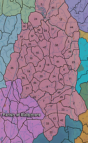
The townland of Ballynaleck is in the parish of Ballymore in Armagh County. It is labelled number 7 on the map.
The Environment and Heritage Service Sites and Monuments Record (2002) notes the following in this townland:
Enclosure of uncertain period
SMR NO: ARM 018:022
Irish Grid Reference: J03403829
Townland: BALLYNALECK
CONDITION: No visible remains
A small circular "Fort" c.30m in idam. is shown on the OS 6" map of 1835. This was reduced to a "Site of Fort" incorporated into field boundaries on the 1863 edition. All that survives is a curved section of a field boundary which follows the S side of the monument. The low hedge bank is modern, but it may be significant that the interior around this is raised some O.9m above the ground level outside, perhaps indicating that the site once consisted of a low platform.
Enclosure of uncertain period
SMR NO: ARM 018:023
Irish Grid Reference: J03643819
Townland: BALLYNALECK
CONDITION: No visible remains
An irregular, but rougly circular "Fort" c.35m across is marked on the OS 6" map of 1835. By the time of the 1863 edition only a "Site of Fort" incorporated into the field boundaries is indicated. The site was on a slight SE-facing slope overlooking a small marshy area, but no trace of the monument can be seen.
Rath of the Early Christian Period.
SMR NO: ARM 018:025
Irish Grid Reference: J03533781
Townland: BALLYNALECK
CONDITION: traces only
A circular "Fort c.40m in diam. is shown on the OS 6" map of 1835, but only a "Site of Fort" is indicated on the 1863 edition. The monument was on a slight eminence, overlooked by higher ground N & W. Only a very faint domed mound can be identified. A steep scarp falling 2m is preserved by the field boundary c.1 5m SE of the position shown on the earlier OS maps for the perimeter of the site. Although this may be part of the monument, it could simply be accumulation of soil against a field boundary.
PRONI records: VAL/1B/214 (1st Valuation Records); D.476/37 (Rent roll.); OS/6/2/18/1 (Surveyed 1835. Engraved 1835.); OS/6/2/18/2 (Surveyed 1835. Engraved 1835. Revised 1860. Engraved 1863.); OS/6/2/18/3 (Surveyed 1835. Revised 1906. Published 1908.); OS/6/2/18/4 (Surveyed 1835. Revised 1906. Published 1908. (2 copies - 1st a reprint 1930, 1933 and 2nd reprint 1933, 1939, 1942, 1946, 1955.); OS/6/2/18/5 (Surveyed 1906. Revised 1954-5. Levelled 1892, 1901-2, 1904 and 1906. Published 1958 (2 copies).); VAL/12B/15/23A, VAL/12B/15/23B, VAL/12B/15/23C, VAL/12B/15/23D, VAL/12B/15/23E (Valuation annual revision list.); VAL/2B/2/32C (Griffith valuation list.).
