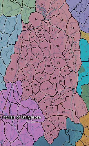
The townland of Ballysheil Beg is in the parish of Ballymore in Armagh County. It is labelled number 9 on the map.
The Environment and Heritage Service Agency Sites and Monuments Record (2002) notes the following in this townland:
Rath from the Early Christian period
SMR NO: ARM 017:006
GRIDREF: J01424227
"A low oval platform ,S of the summit of a drumlin, has survived despite erosion by cultivation. Around the N, only a very gentle scarp, falling 0.6m marks the perimeter, while to the S, the edge is preserved by incorporation into a field boundary. Here there is a steep scarp dropping c.1.2m to the surrounding ground level. A recent drainage ditch also curves round this side of the site. The site is shown on the OS 6" maps of 1835 & 1863 - the 1863 map suggests a circular site c.50m in diam.
BIBLIOGRAPHY:
O.S. MEM BALLYMORE: BENNET, 1835, SH.2, 3."An enclosure of uncertain period.
SMR NO: ARM 017:007
GRIDREF: J01854207
"A "Fort" is indicated on the OS 6" map of 1835, and a circular earthwork c.50m in diam. is shown on the 1863 edition. The site was slightly N of the top of a low, rounded hillock."Rath from the Early Christian period
SMR NO: ARM 017:053
GRIDREF: J01134162
CONDITION: DESTROYED
"Local information suggests that there was once a "fort" on an eminence overlooking the valley of a small stream which forms the townland boundary to the W. A track to the N & farm buildings to the E have removed almost all trace of the monument, but a pronounced scarp which merges into the naturally steep slope, can be identified on the W. The perimeter on this side was once marked by a bank but this was bulldozed over the edge of the slope in the 1960s.
BIBLIOGRAPHY: O.S. MEM BALLYMORE: BENNETT, 1835, S.2 BOX 18, 3."
PRONI records: OS/6/2/13/1 (Surveyed 1834-35. Engraved 1835.); OS/6/2/13/2 (Surveyed 1834-35. Revised 1860. Engraved 1863 (Stat file copy).); OS/6/2/13/3 (Surveyed 1834-35. Revised 1905-06. Published 1930.); OS/6/2/13/4 (Surveyed 1905-06. Revised 1954-55. Levelled 1888 and 1892 and 1902, 1905-1906. Levels part revised 1948. Published 1958. (2 copies).); OS/6/2/17/1 (Surveyed 1835. Engraved 1835.); OS/6/2/17/2 (Surveyed 1835. Engraved 1835. Revised 1860. Engraved 1863.); OS/6/2/17/3 (Surveyed 1835. Revised 1906. Published 1908. Reprinted 1929, 1932.); OS/6/2/17/4 (Surveyed 1906. Revised 1954-5. Levelled 1889, 1892 and 1906. Published 1958 (2 copies).); VAL/1B/214 (1st valuation records.); VAL/12B/11/1A, VAL/12B/11/1B, VAL/12B/11/1C, VAL/12B/11/1D, VAL/12B/11/1E (Valuation annual revision list.); VAL/2B/2/32AC 1863 (Griffith valuation list.C 1863); VAL/12B/11/5A (Valuation annual revision list.).
