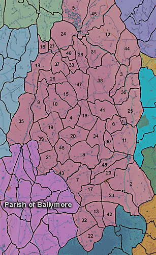
The townland of Corernagh is in the parish of Ballymore in Armagh County. It is labelled number 18 on the map.
The Environment and Heritage Service Sites and Monuments Record (2002) notes the following in this townland:
Platform rath of the Early Christian Period.
SMR NO: ARM 018:009
Irish Grid Reference: J03634113
Townland: CORERNAGH
CONDITION: some remains
In spite of cultivation which has eroded the N & E sides it is possible to identify a low, flat-topped, circular platform 31m in diam. Only a faint scarp falling no more than 0.4m survives on N & E, but hedge boundaries on the S & W have helped preserve this portion of the perimeter. On the W is a steep scarp which drops c.1.7m to the base of a recut ditch 3m wide & 0.5m deep. A road curves round the S side c.1 m below the interior, and perhaps follows the line of the external ditch.
Enclosure of uncertain period
SMR NO: ARM 018:041
Irish Grid Reference: J0341
Townland: CORERNAGH
CONDITION: Not precisely located.
BIBLIOGRAPHY:
PATERSON, T. G. F. NOTES Vol. 135
PRONI records: FIN.23/2/2B/1267 (Landlord Duke of Manchester re Henry Harden, tenant.); FIN.23/2/2B/1268 (Landlord Duke of Buccleuch re Henry Harden, tenant.); OS/6/2/18/1 (Surveyed 1835. Engraved 1835.); OS/6/2/18/2 (Surveyed 1835. Engraved 1835. Revised 1860. Engraved 1863.); OS/6/2/18/3 (Surveyed 1835. Revised 1906. Published 1908.); OS/6/2/18/4 (Surveyed 1835. Revised 1906. Published 1908. (2 copies - 1st a reprint 1930, 1933 and 2nd reprint 1933, 1939, 1942, 1946, 1955.); OS/6/2/18/5 (Surveyed 1906. Revised 1954-5. Levelled 1892, 1901-2, 1904 and 1906. Published 1958 (2 copies).); VAL/1B/214 (1st valuation records.); VAL/12B/11/1A, VAL/12B/11/1B, VAL/12B/11/1C, VAL/12B/11/1D, VAL/12B/11/1D, VAL/12B/11/1E (Valuation annual revision list.); VAL/2B/2/32BC 1863 (Griffith valuation list.C 1863).
