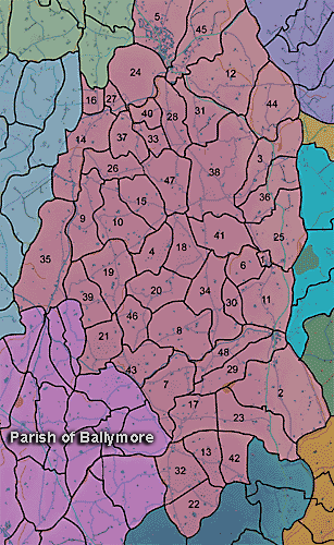
The townland of Corlust is in the parish of Ballymore in Armagh County. It is labelled number 19 on the map.
The Environment and Heritage Service Sites and Monuments Record (2002) notes the following in this townland:
Enclosure of uncertain period
SMR NO: ARM 017:036
GRIDREF: J01614083
CONDITION: NO VISIBLE REMAINS
"A circular "Fort" is indicated on the 1835 OS 6" map, and a circular earthwork, c.45m in diam. is shown on the 1863 edition. The site was on the top of a low, natural eminence with quite extensive views, especially to the W & N. No visible trace remains.
BIBLIOGRAPHY:
O.S. MEM BALLYMORE: BENNET, 1835, 5.2, 4"Standing stone of uncertain, prehistoric period.
SMR NO: ARM 017:048
GRIDREF: J01564103
CONDITION: NO VISIBLE REMAINS
"In his notes, Paterson recorded a standing stone c.1.5m high used as a gate post on Pillar Hill, but it has since been removed. It is said to have been of granite and measured 0.46m thick.
BIBLIOGRAPHY: PATERSON,T.G.F. NOTES VOL.134"'Burial Thorn' folklore site of the modern period.
SMR NO: ARM 017:052
GRiDREF: J01614093
CONDITION: DESTROYED
"The Burial Thorn was so named because a woman hanged herself and was buried under it. It has been removed by the construction of a new road."Enclosure of uncertain period.
SMR NO: ARM 017:056
GRIDREF: J0241
"Not precisely located."Enclosure of uncertain period.
SMR NO: ARM 017:057
GRIDREF: J0241
"Not precisely located.
BIBLIOGRAPHY: ~ PATERSON,T.G.F. NOTES VOL. 135."Oval enclosure of uncertain period noted on an aerial photograph.
SMR NO: ARM 017:062
GRIDREF: J02214156
CONDITION: TRACES ONLY
"An oval enclosure, c.60m x c.45m which showed up on APs [aerial photographs]. It is of a relief ditched enclosure, with a raised platform -like interior. It is situated under grass on the level of a hill. Not visited."
PRONI records: D.943/2 (Graham estate.); OS/6/2/17/1 (Surveyed 1835. Engraved 1835.); OS/6/2/17/2 (Surveyed 1835. Engraved 1835. Revised 1860. Engraved 1863.); OS/6/2/17/3 (Surveyed 1835. Revised 1906. Published 1908. Reprinted 1929, 1932.); OS/6/2/17/4 (Surveyed 1906. Revised 1954-5. Levelled 1889, 1892 and 1906. Published 1958 (2 copies).); OS/6/2/18/1 (Surveyed 1835. Engraved 1835.); OS/6/2/18/2 (Surveyed 1835. Engraved 1835. Revised 1860. Engraved 1863.); OS/6/2/18/3 (Surveyed 1835. Revised 1906. Published 1908.); OS/6/2/18/4 (Surveyed 1835. Revised 1906. Published 1908. (2 copies - 1st a reprint 1930, 1933 and 2nd reprint 1933, 1939, 1942, 1946, 1955.); OS/6/2/18/5 (Surveyed 1906. Revised 1954-5. Levelled 1892, 1901-2, 1904 and 1906. Published 1958 (2 copies).); VAL/1B/214 (1st valuation records.); VAL/12B/11/1A, VAL/12B/11/1B, VAL/12B/11/1C, VAL/12B/11/1D, VAL/12B/11/1D, VAL/12B/11/1E (Valuation annual revision list.); VAL/2B/2/32AC 1863 (Griffith valuation list.C 1863).