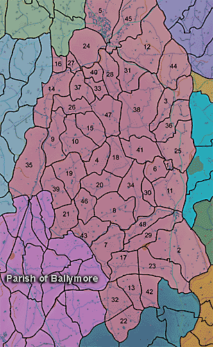
The townland of Demoan is in the parish of Ballymore in Armagh County. It is labelled number 23 on the map.
In 1838:
"There are no natural woods in this parish. It, however, contains about 403 acres of forest trees, of which 95 acres are in Derryallen, 75 in Skigatallagh,16 in Demone, 50 in Brannock, 40 in Clare, 25 in Cargans, 20 in Druminaleg, 14 in Tullyhue, 12 in Moodoge and 12 in Druminure." (Ordnance Survey Memoirs 1835-38)
The Environment and Heritage Service Sites and Monuments Record (2002) notes the following in this townland:
Rath of the Early Christian Period.
SMR NO: ARM 018:027
Irish Grid Reference: J04733766
Sitename: BANKER'S FORT
Townland: DEMOAN
CONDITION: some remains
An oval earthwork is indicated on the 1835 OS 6" map, but on the 1863 edition on the W half is shown. The outline of the E side can still be seen as a low scarp falling 1 m, but this has been eroded by cultivation. On the NNW a bank 4m wide & 1.2m high above the interior gives an indication of the original proportions. From the top of the bank there is a fall of 3.5m to the base of an external ditch c.4m wide x 0.75-1m deep. The site is 56m NNE-SSW x 50m WNWESE. See SM7 for further details & measurments.
BIBLIOGRAPHY:
O. S. FIELD REPORT NO.53, 12
Rath? of the Early Christian Period and Eighteenth or Nineteenth Century tree ring?.
SMR NO: ARM 018:028
Irish Grid Reference: J05343764
Townland: DEMOAN
CONDITION: traces only
The site of a roughly circular "Fort" bordered on W & N by a curving farm track is shown on the 1863 OS 6" map. The earlier map simply indicates a circular plantation of trees. The S side has been ploughed level, but the arc of a hedge survives around the N. A ditch around the N also appears to be modern, and the slightly domed interior might favour interpretation as a landscaping feature rather than a rath. The surviving portion measures 40m NE-SW. Locally it was known as "the forth".
PRONI records: OS/6/2/18/1 (Surveyed 1835. Engraved 1835.); OS/6/2/18/2 (Surveyed 1835. Engraved 1835. Revised 1860. Engraved 1863.); OS/6/2/18/3 (Surveyed 1835. Revised 1906. Published 1908.); OS/6/2/18/4 (Surveyed 1835. Revised 1906. Published 1908. (2 copies - 1st a reprint 1930, 1933 and 2nd reprint 1933, 1939, 1942, 1946, 1955.); OS/6/2/18/5 (Surveyed 1906. Revised 1954-5. Levelled 1892, 1901-2, 1904 and 1906. Published 1958 (2 copies).); OS/6/2/22/1 (Surveyed 1835. Engraved 1835.); OS/6/2/22/2 (Surveyed 1835. Engraved 1835. Revised 1861. Engraved 1863.); OS/6/2/22/3 (Surveyed 1835. Revised 1906. Published 1908 (2 copies - 1 reprint 1930 and 1 reprint 1930-1955.).); OS/6/2/22/4 (Surveyed 1906. Revised 1955. Levelled 1889 and 1906. Published 1959 (2 copies).); VAL/1B/214 (1st valuation records.); VAL/12B/15/23A, VAL/12B/15/23B, VAL/12B/15/23C, VAL/12B/15/23D, VAL/12B/15/23E (Valuation annual revision list.); VAL/2B/2/32E (Griffith valuation list.).
