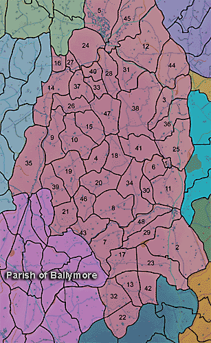
The townland of Derryallen is in the parish of Ballymore in Armagh County. It is labelled number 24 on the map.
In 1838:
"There are no natural woods in this parish. It, however, contains about 403 acres of forest trees, of which 95 acres are in Derryallen, 75 in Skigatallagh,16 in Demone, 50 in Brannock, 40 in Clare, 25 in Cargans, 20 in Druminaleg, 14 in Tullyhue, 12 in Moodoge and 12 in Druminure." (Ordnance Survey Memoirs 1835-38)
Paterson (Armachiana, Vol. 16, p.212 ) notes:
PRONI records: OS/6/2/13/1 (Surveyed 1834-35. Engraved 1835.); OS/6/2/13/2 (Surveyed 1834-35. Revised 1860. Engraved 1863 (Stat file copy).); OS/6/2/13/3 (Surveyed 1834-35. Revised 1905-06. Published 1930.); OS/6/2/13/4 (Surveyed 1905-06. Revised 1954-55. Levelled 1888 and 1892 and 1902, 1905-1906. Levels part revised 1948. Published 1958. (2 copies).); OS/6/2/14/1 (Surveyed 1834-35. Engraved 1835.); OS/6/2/14/2 (Surveyed 1834. Revised 1860. Engraved 1863 (Stat file copy).); OS/6/2/14/3 (Surveyed 1834-35. Revised 1906. Published 1908. Reprinted 1929. (2 copies).); OS/6/2/14/4 (Surveyed 1834-35. Revised 1906. Levelled 1905-06.Published 1908. Reprint 1951 and 1958.); OS/6/2/14/5 (Surveyed 1834. Revised 1860. Engraved 1863 (Stat file copy). Reprinted 1937 with mss markings in red and stamped ref 2569, 2570.); OS/6/2/14/6 (Surveyed 1906. Revised 1954. Levelled 1892, 1902 and 1904-06. Published 1958 (2 copies).); VAL/1B/214 (1st valuation records.); VAL/12B/11/5B, VAL/12B/11/5C, VAL/12B/11/5D, VAL/12B/11/5E, VAL/12B/11/5F, VAL/12B/11/5G (Valuation annual revision list.); VAL/2B/2/32BC 1863, VAL/2B/2/32BC 1863 (Griffith valuation list.C 1863).