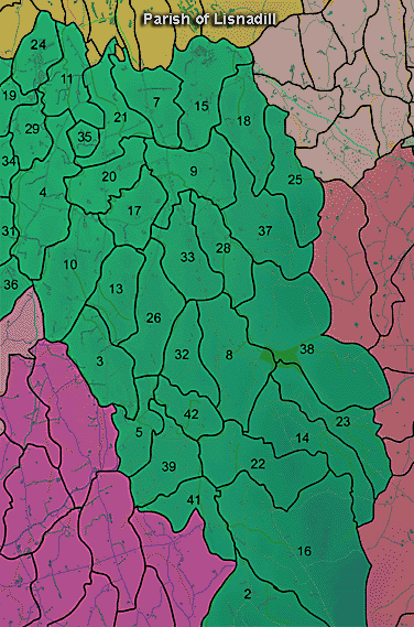
The townland of Drumconwell is in the parish of Lisnadill in Armagh County. It is labelled number 17 on the map. H875408
Paterson (Armachiana, Vol. 16, p.21) notes:
The Environment and Heritage Service Sites and Monuments Record (2002) notes the following in this townland:
Rath of the Early Christian Period.
SMR NO: ARM 016:010
Irish Grid Reference: H87344026
Townland: DRUMCONWELL
CONDITION: some remains
A circular platform, 45m E-W x 45.5m N-S has been levelled out of the hill side, so that on S it rises c.2.5m above ground level while at N it is almost level. A bank, c.6m wide & 1 m high encloses the N half of the site. This slopes down to an overgrown ditch c.3m deep below the top of the inner bank & c.4.5m wide. At S, the perimeter is marked by a steep scarp, falling c.3m to the base of the ditch. An outer bank rises 2-2.5m above the ditch. The site is now used as a dump for derelict vehicles.
Ecclesiastical site ? and ogham stone of the Early Christian Period.
SMR NO: ARM 016:046
Irish Grid Reference: H87804020
Sitename: KILLAFADDY, DRUMCONWAYLL, THE GRAVEYARD FIELD
Townland: DRUMCONWELL
CONDITION: No visible remains
The area of the site is still known as "the graveyard field" and located on a N-S drumlin ridge, surrounded by a slight scarp. The ogham stone found in this field by the present owner's greatgrandfather is now set into the vestibule of the Diocesan library in Armagh. There are now no visible remains of the Church site or graveyard, but on a recent visit, Richard Warner of the Ulster Museum found a quern stone. See SM7 file for futher details on site & ogham stone.
BIBLIOGRAPHY:
J. R. S. A. I., XVI, 1883-4, 432
LETT, JRSAI XVII, 1885, 163-5
MACALISTER, R. A. S.1945, 298-9, & FIG. P.299
PATERSON, T. G. F. NOTES, Vol. 135
REEVES, W. JRSAI XVI, 1883-4, 367-70 & MSS NOTES, 1879
RHYS, JRSAI XXV, 102
www.ucl.ac.uk/archaeology/cisp/database/site/drcrom.htm
PRONI records: OS/6/2/16/1 (Surveyed 1834-35. Engraved 1835.); OS/6/2/16/2 (Surveyed 1834-35. Engraved 1835. Revised 1860. Engraved 1862.); OS/6/2/16/3 (Surveyed 1834-35. Revised 1906. Levelled 1888-89 and 1906. Published 1908. Reprint 1952, 1954.); OS/6/2/16/4 (Surveyed 1834-35. Revised 1906. Levelled 1888-89 and 1906. Published 1908. Reprint 1929.); OS/6/2/16/5 (Surveyed 1834-35. Revised 1906. Levelled 1888-89 and 1906. Published 1908. Reprint 1952, 1954 with Mss. markings in red and stamped ref. 2568.); OS/6/2/16/6 (Surveyed 1906. Revised 1955. Levelled 1906. Published 1958. (2 copies).); VAL/1B/211 (1st valuation records.); VAL/12B/10/9A, VAL/12B/10/9B, VAL/12B/10/9C, VAL/12B/10/9D, VAL/12B/10/9E (Valuation annual revision list.); VAL/2B/2/10A, VAL/2B/2/10A (Griffith valuation list.).

In the accompanying recording, Mavis Crozier and her granddaughter Alison talk about the Drumconwell rath and other features of the townland of Drumconwell.

Use the audio controller to listen to this talk, given in 2003.


