 H895424
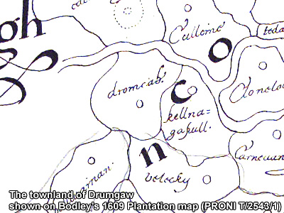
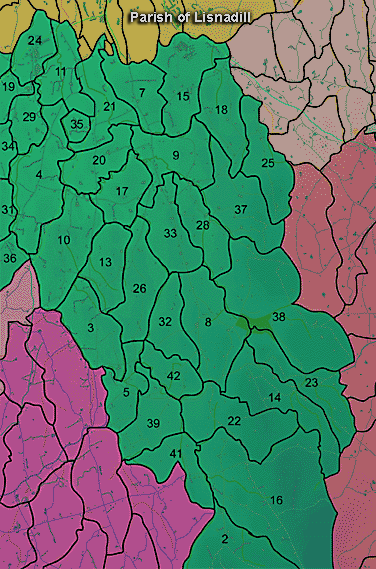
The townland of Drumgaw is in the parish of Lisnadill in Armagh County. It is labelled number 18 on the map.
Paterson (Armachiana, Vol. 16, p.21) notes:
The Environment and Heritage Service Sites and Monuments Record (2002) notes the following in this townland:
Rath of the Early Christian Period and landscape feature of the Eighteenth Century/Nineteenth Century.
SMR NO: ARM 016:005
Irish Grid Reference: H89854204
Townland: DRUMGAW
CONDITION: some remains
The interior of this circular earthwork has been built up c.1.3m on the NE to counteract the natural slope & create a level platform 39m in diam. It in enclosed on N, E & S by a steep sided bank surmounted by a hedge & beyond this by a recut ditch. At W, the perimeter has been levelled & only a slight scarp survives. The bank is most substantial on S where it is c.3.5m wide & O.9m high above the interior. The ditch also varies - 3m x 0.6 m deep at S to less that 2m wide at NE. See SM7 for further details.
Ecclesiastical site (church and graveyard) of uncertain period
SMR NO: ARM 016:062
Irish Grid Reference: H89954260
Townland: KILLYCAPPLE, DRUMGAW
CONDITION: no visible remains
The area has been generally improved. The hill slopes down to the N/NW but gives way to a relatively level platform bounded by the river at N & the stream at W. There are no surface indications of a church. The platform could easily have accomodated an E-W structure.
BILIOGRAPHY:
PATERSON, T. G. F. NOTES, Vol. 135
Enclosure of uncertain period
SMR NO: ARM 016:070
Irish Grid Reference: H8942
Townland: DRUMGAW
Not precisely located.
BIBLIOGRAPHY:
PATERSON, T. G. F. NOTES, Vol. 135
PRONI records: D.3478 (Marriage settlement between Arthur Graham and Penelope Ligonier.); D.1607/12; [see also D.1607/14] (Property of representatives of James McCullough and William Simpson: rentals, accounts and correspondence [reps W.H. Edwards and Miss Ethel Edwards].); D.943/2 (Graham estate.); OS/6/2/12/1 (Surveyed 1835. Engraved 1835.); OS/6/2/12/2 (Surveyed 1835. Revised 1860. Engraved 1860 (Stat file copy).); OS/6/2/12/3 (Not Received.); OS/6/2/12/4 (Surveyed 1835. Revised 1905-06. Reprinted 1931-1947. Published 1931 with mss markings in red and stamped references 2566, 2567, 2573.); OS/6/2/12/5 (Surveyed 1906. Revised 1948. Levelled 1888 and 1906. Levels revised 1949. Published 1953. (2 copies) - 1 being reprint 1953, 56, 61).); OS/6/2/16/1 (Surveyed 1834-35. Engraved 1835.); OS/6/2/16/2 (Surveyed 1834-35. Engraved 1835. Revised 1860. Engraved 1862.); OS/6/2/16/3 (Surveyed 1834-35. Revised 1906. Levelled 1888-89 and 1906. Published 1908. Reprint 1952, 1954.); OS/6/2/16/4 (Surveyed 1834-35. Revised 1906. Levelled 1888-89 and 1906. Published 1908. Reprint 1929.); OS/6/2/16/5 (Surveyed 1834-35. Revised 1906. Levelled 1888-89 and 1906. Published 1908. Reprint 1952, 1954 with Mss. markings in red and stamped ref. 2568.); OS/6/2/16/6 (Surveyed 1906. Revised 1955. Levelled 1906. Published 1958. (2 copies).); VAL/1B/29A, VAL/1B/211 (1st valuation records.); VAL/12B/10/29A, VAL/12B/10/29B, VAL/12B/10/29C, VAL/12B/10/29D (Valuation annual revision list.); VAL/2B/2/12B (Griffith valuation list.); T.579/55 (Landed estates rental.29 Jan. 1869).
H895424