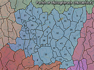
The townland of Drumman is in the parish of Mullaghbrack in Armagh County. It is labelled number 18 on the map.
Paterson (Armachiana, Vol. 16, p.21) notes:
The Environment and Heritage Service Sites and Monuments Record (2002) notes the following in this townland:
Rath of the Early Christian Period.
SMR NO: ARM 013:011
Grid Ref: H94884551
Townland: DRUMMAN
Sitename: DRUMMAN FORT
Condition: some remains
On the summit of a low rounded hill, the site is poorly preserved, but its roughly circular outline is defined by a hedge boundary and lane on the SE, and by a shallow scarp which falls up to 1.2m to the base of a shallow surrounding ditch. The platform measures 45m across N-S and the ditch appears to be c.5.5m wide and no more than 0.2m deep. The site has been heavily ploughed and the NE quadrant is almost completely destroyed.
PRONI records: OS/6/2/13/1 (Surveyed 1834-35. Engraved 1835.); OS/6/2/13/2 (Surveyed 1834-35. Revised 1860. Engraved 1863 (Stat file copy).); OS/6/2/13/3 (Surveyed 1834-35. Revised 1905-06. Published 1930.); OS/6/2/13/4 (Surveyed 1905-06. Revised 1954-55. Levelled 1888 and 1892 and 1902, 1905-1906. Levels part revised 1948. Published 1958. (2 copies).); VAL/1B/213 (1st valuation records.); VAL/12B/10/24A, VAL/12B/10/24B, VAL/12B/10/24C, VAL/12B/10/24D (Valuation annual revision list.); VAL/2B/2/12A (Griffith valuation list.); VAL/1B/29A (1st Valuation Records.).
