 H953431
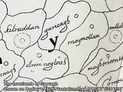
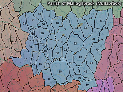
The townland of Garvagh is in the parish of Mullaghbrack in Armagh County. It is labelled number 24 on the map.
The Environment and Heritage Service Sites and Monuments Record (2002) notes the following in this townland:
Enclosure of uncertain period, possibly rath of the Early Christian Period.
SMR NO: ARM 013:029
Grid Ref: H95004294
Townland: GARVAGH
Condition: traces only
On top of a prominent drumlin with extensive views all round. A "Fort" c.30m in diam. is marked on the OS 6" map of 1835, and traces survived, preserved in the later hedge boundaries, until these were removed in recent years. A farmhouse appears to have been build hard against the E side of the site, and the scarp now seen on the side is probably not original.
PRONI records: D.943/2 (Graham estate.); D.1606/6E/7 (Map of townland of Garvagh, being part of estate of Rev. John Graham [Clark], surveyed in Nov. 1739by [Ar] Hardy.); OS/6/2/13/1 (Surveyed 1834-35. Engraved 1835.); OS/6/2/13/2 (Surveyed 1834-35. Revised 1860. Engraved 1863 (Stat file copy).); OS/6/2/13/3 (Surveyed 1834-35. Revised 1905-06. Published 1930.); OS/6/2/13/4 (Surveyed 1905-06. Revised 1954-55. Levelled 1888 and 1892 and 1902, 1905-1906. Levels part revised 1948. Published 1958. (2 copies).); OS/6/2/17/1 (Surveyed 1835. Engraved 1835.); OS/6/2/17/2 (Surveyed 1835. Engraved 1835. Revised 1860. Engraved 1863.); OS/6/2/17/3 (Surveyed 1835. Revised 1906. Published 1908. Reprinted 1929, 1932.); OS/6/2/17/4 (Surveyed 1906. Revised 1954-5. Levelled 1889, 1892 and 1906. Published 1958 (2 copies).); VAL/1B/213 (1st valuation records.); VAL/12B/10/24A, VAL/12B/10/24B, VAL/12B/10/24C, VAL/12B/10/24D (Valuation annual revision list.); VAL/2B/2/12A (Griffith valuation list.).
H953431