 H967409
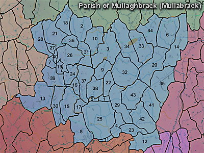
The townland of Gosford Demesne is in the parish of Mullaghbrack in Armagh County. It is labelled number 25 on the map.
The 1826 Schools Commission report describes the school in the townland:
"Gosford, Cabra - A free school under the care of Thomas and Mary Woodhouse, of the Church of Ireland denomination, who were in receipt of 40l per annum. The school was held in a good house, built at a cost of 200-250l. The school was under the patronage of the Earl and Countess of Gosford who paid the salary and built the school. The school provided education for 130 scholars."
It was described in 1838 in the Ordnance Survey Memoirs:
The Environment and Heritage Service Sites and Monuments Record (2002) notes the following in this townland:
Gosford castle
SMR NO: ARM 017:010
GRIDREF: H96354060
"The site was recorded in Co.Armagh directory: '...Small ancient building etc. that is the remains of the second Gosford castle and is the house in which Dean Swift was from time to time a guest ... The first castle or bawn was destroyed in 1641.' "Enclosure of uncertain period
SMR NO: ARM 017:032
GRIDREF: H96754122
CONDITION: NO VISIBLE REMAINS
"A small circular "Fort" planted with trees and measuring c.30m in diam. is shown on the 1835 OS 6" map. The site is now occupied by a picnic spot surrounded by conifers in Gosford Forest Park, & no trace of an antiquity can be seen."Greer's Fort
Rath of Early Christian Period
SMR NO: ARM 017:033
GRIDREF: H97204139
CONDITION: SOME REMAINS
"The interior of the site, now a picnic spot, is raised to maintain a level platform as the ground slopes. The W side is marked by a steep scarp falling 1.5m to the base of the ditch, 4m wide and approx. 0.5m deep. A bank, also c.4m wide encloses the N, E & S sides, standing c.1.2m above the interior but becoming lower towards the W. The site measures 47.5m N-S x 46.5m E-W. The ditch continues right round the site, but has been modified at E. 2 gaps at NW & SE provide access - the NW may be original. See SM7 file."Crunaght Fort
SMR NO: ARM 017:034
GRIDREF: H97084012
CONDITION: SOME REMAINS
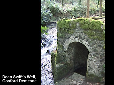
"The circular earthwork is very overgrown & the N portion of the perimeter has been removed by a forestry road. A low platform, 0.6m above the outer ground, is enclosed on the E, S & W sides by the remains of a low bank 0.3m above the interior & spread 2.5m wide. The monument measures 32m E-W x 33. 5m N-S. Beyond the bank the ground falls gradually c.1.2m to the base of a shallow silted ditch c.4.5m wide & 0.6m deep. A gap 2.5m wide through the bank at SE is perhaps the original entrance."SWIFT'S WELL, SAINT PATRICK'S WELL
SMR NO: ARM 017:051
GRIDREF: H96334053
CONDITION: WELL PRESERVED
"The well was a place of pilgrimage & was known as St. Patrick's Well, but it is now commonly called "Dean Swift's Well", due to his frequent visits to it during his stay at Markethill 1727-29. It is located in Gosford Forest Park & is a signposted feature of a forest walk. It is reported to have been in continuous use for a long time. It is set on the N bank of a small stream which flows from an ornamental lake 100m W. The well house covering the well is part of the C18th landscaping of the estate.
BIBLIOGRAPHY: PATERSON,T.G.F. UJA 11, 1948, 128"Enclosure of uncertain period
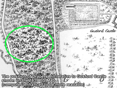
SMR NO: ARM 017:055
GRIDREF: H97144100
"The site was shown as a circular feature on the 1847 Estate Map of Gosford Demesne by Alexander Richard. No other information available.
PRONI records: D.1606/6A/1 (Working plan of Gosfort Demesne.C 1800); T.3323 (Photographs of castle and china porcelain.); D.1606 (Gosford correspondence re building materials for Gosford Castle.); D.1618/18/11 (Album of photographs of Armagh and Tyrone sceneryincluding exterior of Gosford Castle.); D.1606/6A/3 (Rough map and elevation of intended approach to Gosford Castle.C 1834); D.1606/6A/4 (Rough plan of intended approach to Gosford Castleby Alex? Richmond.); D.1606/6A/5 (Plan and section of intended approach and back entrance to gosford Castle, by Alex? Richmond.); D.3520 (Sale catalogue of contents of castle.); T.2437/1-2 (2 copies of sale catalogue.); D.603 (Survey.); OS/6/2/17/1 (Surveyed 1835. Engraved 1835.); OS/6/2/17/2 (Surveyed 1835. Engraved 1835. Revised 1860. Engraved 1863.); OS/6/2/17/3 (Surveyed 1835. Revised 1906. Published 1908. Reprinted 1929, 1932.); OS/6/2/17/4 (Surveyed 1906. Revised 1954-5. Levelled 1889, 1892 and 1906. Published 1958 (2 copies).); VAL/1B/213 (1st valuation records.); VAL/12B/10/34A, VAL/12B/10/34B, VAL/12B/10/34C, VAL/12B/10/34D (Valuation annual revision list.); VAL/2B/2/12A (Griffith valuation list.); D.2557 (Photographs of architectural details of Gosfort Castle.C 1968); T.1417 (Sale catalogue of furniture, etc.); T.1460 (Military billeting plans.); D.1664 (13 photographs.).
H967409