 H993384
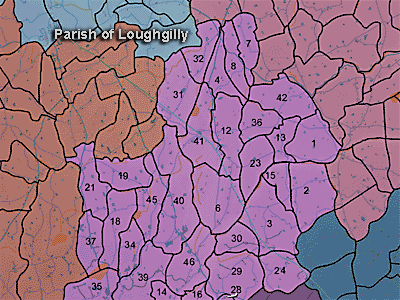
The townland of Killycarn Lower is in the parish of Loughgilly in Armagh County. It is labelled number 31 on the map.
The Environment and Heritage Service Sites and Monuments Record (2002) notes the following in this townland:
Rath from the Early Christian period
SMR NO: ARM 017:012
GRIDREF: J00043971
CONDITION: TRACES ONLY
"A roughly circular "Fort" c.50m in diam. is marked on the OS 6" map of 1835. By the time of the 1863 edition, most of the N side was removed by farm track. Field reports of the 1 960s record that the N half of the perimeter was lost and only the arc of a bank had survived, standing 1.8m high around the S. Traces of an external ditch were also recorded. There are now no visible remains other than a pronounced scarp on the SW which merge with the naturally precipitous slope."
PRONI records: OS/6/2/17/1 (Surveyed 1835. Engraved 1835.); OS/6/2/17/2 (Surveyed 1835. Engraved 1835. Revised 1860. Engraved 1863.); OS/6/2/17/3 (Surveyed 1835. Revised 1906. Published 1908. Reprinted 1929, 1932.); OS/6/2/17/4 (Surveyed 1906. Revised 1954-5. Levelled 1889, 1892 and 1906. Published 1958 (2 copies).); VAL/1B/219 (1st valuation records.); VAL/12B/15/19A, VAL/12B/15/19B, VAL/12B/15/19C, VAL/12B/15/19D, VAL/12B/15/19E (Valuation annual revision list.); VAL/2B/2/34A (Griffith valuation list.).
H993384