 H954375
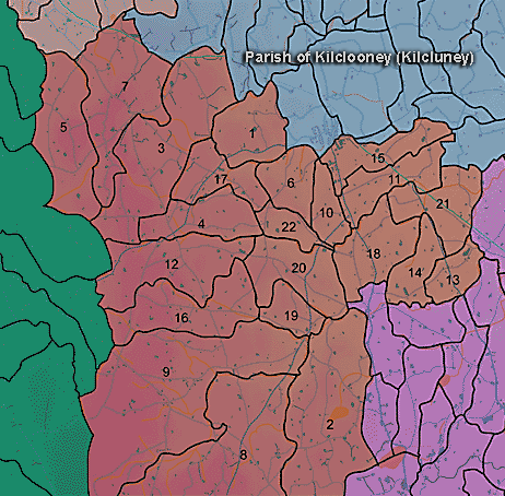
The townland of Lisnagat is in the parish of Kilclooney in Armagh County. It is labelled number 20 on the map.
The Environment and Heritage Service Sites and Monuments Record (2002) notes the following in this townland:
"Blair's Cave", an enclosure of uncertain, possibly Early Christian,
period.
SMR NO: ARM 017:039
GRIDREF: H95863663
CONDITION: NO VISIBLE REMAINS
"The 1863 OS 6" map shows a large oval earthwork c.165m NE-SW x 145m
NW-SE. The S perimeter was once preserved by a field boundary, but this area
is now occupied by bungalows & gardens. The remaining circumference has also
been lost & there are no visible remains. The site is bisected by a steep-sided
stream valley which forms the townland boundary [between Lisnagat and Kilmachugh].
Paterson refers to "Blair's Cave" on a bank of the river. The entrance was
blocked but it is possible that it was a souterrain (the souterrain is in
Lisnagat townland - see Arm 017:049). The bridge to N is called Blairs Bridge.
BIBLIOGRAPHY: PATERSON,T.G.F. MS.135 "
"Blair's Cave" Souterrain from the Early Christian Period
SMR NO: ARM 017:049
GRIDREF: H95863663
CONDITION: NO VISIBLE REMAINS
" See description [above] and SM7 file for ARM 017:039."
Enclosure of uncertain period
SMR NO: ARM 021:043
Irish Grid Reference: H96293643
Townland: LISNAGAT
CONDITION: No visible remains
On the 1863 OS 6"map a "Site of Fort" c.30m in diam. is indicated by a small pecked circle. A portion of the bank of this feature may be shown on the earlier 1835 map N of the county road which cuts across the site. This road has recently been widened & all trace of the monument has been removed, except possibly for a very disturbed bank to S. The site is positioned on top of a slight natural eminence overlooked by higher ground to N but with a very steep drop to the Mowhan river immediately to the S.
PRONI records: D.1524 (Assignment of mortgage.); OS/6/2/17/1 (Surveyed 1835. Engraved 1835.); OS/6/2/17/2 (Surveyed 1835. Engraved 1835. Revised 1860. Engraved 1863.); OS/6/2/17/3 (Surveyed 1835. Revised 1906. Published 1908. Reprinted 1929, 1932.); OS/6/2/17/4 (Surveyed 1906. Revised 1954-5. Levelled 1889, 1892 and 1906. Published 1958 (2 copies).); OS/6/2/21/1 (Surveyed 1834-35. Engraved 1835.); OS/6/2/21/2 (Surveyed 1834-35. Engraved 1835. Revised 1860. Revisions engraved 1863.); OS/6/2/21/3 (Surveyed 1834-35. Revised 1906. Published 1908. Reprinted 1921.); OS/6/2/21/4 (Surveyed 1834-35. Revised 1906. Published 1908. (2 copies), Reprints 1934-1957.); OS/6/2/21/5 (Surveyed 1906. Revised 1955. Levelled 1889 and 1906. Published 1958.); VAL/1B/29A, VAL/1B/210A, VAL/1B/210B (1st valuation records.); VAL/12B/10/34A, VAL/12B/10/34B, VAL/12B/10/34C, VAL/12B/10/21A, VAL/12B/10/21B (Valuation annual revision list.); VAL/2B/2/9A (Griffith valuation list.).
 H954375


