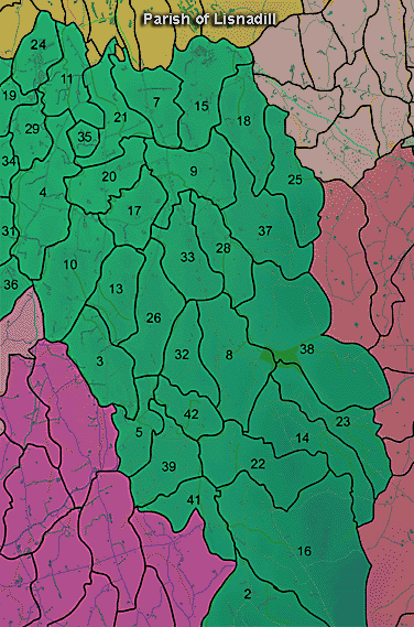
The townland of Magherarville is in the parish of Lisnadill in Armagh County. It is labelled number 34 on the map.
The Environment and Heritage Service Sites and Monuments Record (2002) notes the following in this townland:
SMR NO: ARM 016:074
Irish Grid Reference: H85334139 DRAWNGS: N
Townland: MAGHERARVILLE
CONDITION: traces only
A cropmark of a circular enclosure, c.40m in diam. lt is of a wide continuous bank and an internal wide ditch, also continuous. The middle interior is slightly raised or domed, but has no features in it. It is situated under crop, disected by a field boundary and on a level of land beside the Callan River. Not visited.
PRONI records: OS/6/2/16/1 (Surveyed 1834-35. Engraved 1835.); OS/6/2/16/2 (Surveyed 1834-35. Engraved 1835. Revised 1860. Engraved 1862.); OS/6/2/16/3 (Surveyed 1834-35. Revised 1906. Levelled 1888-89 and 1906. Published 1908. Reprint 1952, 1954.); OS/6/2/16/4 (Surveyed 1834-35. Revised 1906. Levelled 1888-89 and 1906. Published 1908. Reprint 1929.); OS/6/2/16/5 (Surveyed 1834-35. Revised 1906. Levelled 1888-89 and 1906. Published 1908. Reprint 1952, 1954 with Mss. markings in red and stamped ref. 2568.); OS/6/2/16/6 (Surveyed 1906. Revised 1955. Levelled 1906. Published 1958. (2 copies).); VAL/12B/10/9A, VAL/12B/10/9B, VAL/12B/10/9C, VAL/12B/10/9D, VAL/12B/10/9E (Valuation annual revision list.); VAL/1B/27, VAL/1B29A (1st Valuation Records.).
