 H983339
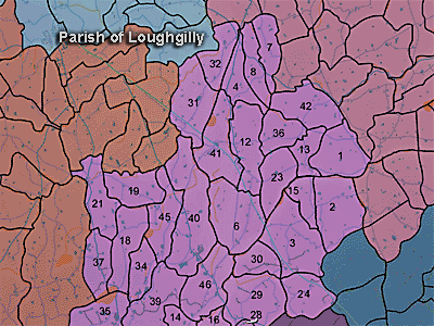
The townland of Maytone is in the parish of Loughgilly in Armagh County. It is labelled number 39 on the map.
The Environment and Heritage Service Sites and Monuments Record (2002) notes the following in this townland:
Enclosure of uncertain period
SMR NO: ARM 021:013
Irish Grid Reference: H98743387
Sitename: STAR HILL
Townland: MAYTONE
CONDITION: No visible remains
A very small circular "Fort" about 25m in diam. is shown on the 1835 OS 6"map. Only a "Site of Fort" is indicated on the 1863 edition and the last vestiges of the perimeter were removed some time before 1967. The site was positioned on the summit of Star Hill and commanded a good view S & E.
PRONI records: OS/6/2/21/1 (Surveyed 1834-35. Engraved 1835.); OS/6/2/21/2 (Surveyed 1834-35. Engraved 1835. Revised 1860. Revisions engraved 1863.); OS/6/2/21/3 (Surveyed 1834-35. Revised 1906. Published 1908. Reprinted 1921.); OS/6/2/21/4 (Surveyed 1834-35. Revised 1906. Published 1908. (2 copies), Reprints 1934-1957.); OS/6/2/21/5 (Surveyed 1906. Revised 1955. Levelled 1889 and 1906. Published 1958.); VAL/1B/219 (1st valuation records.); VAL/12B/15/19A, VAL/12B/15/19B, VAL/12B/15/19C, VAL/12B/15/19D, VAL/12B/15/19E (Valuation annual revision list.); VAL/2B/2/34A (Griffith valuation list.).
 H983339

