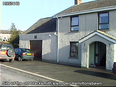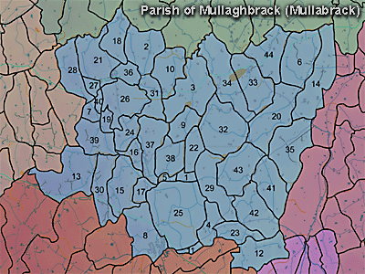
The townland of Mullaghbane is in the parish of Mullaghbrack in Armagh County. It is labelled number 36 on the map. (There is another Mullaghbane in the parish of Kildarton.) H952448. It is the townland of Hamiltonsbawn settlement.
Paterson (Armachiana, Vol. 16, p.24) notes:
Mullaghbane. Mullach signifies the top or summit, and as a root word it forms the beginning of upwards of 400 names. Ban denotes white or whittish. Both words are common in the county in various combinations.
The Environment and Heritage Service Sites and Monuments Record (2002) notes the following in this townland:
PRONI records: OS/6/2/13/1 (Surveyed 1834-35. Engraved 1835.); OS/6/2/13/2 (Surveyed 1834-35. Revised 1860. Engraved 1863 (Stat file copy).); OS/6/2/13/3 (Surveyed 1834-35. Revised 1905-06. Published 1930.); OS/6/2/13/4 (Surveyed 1905-06. Revised 1954-55. Levelled 1888 and 1892 and 1902, 1905-1906. Levels part revised 1948. Published 1958. (2 copies).); OS/6/2/12/1 (Surveyed 1835. Engraved 1835.); OS/6/2/12/2 (Surveyed 1835. Revised 1860. Engraved 1860 (Stat file copy).); OS/6/2/12/3 (Not Received.); OS/6/2/12/4 (Surveyed 1835. Revised 1905-06. Reprinted 1931-1947. Published 1931 with mss markings in red and stamped references 2566, 2567, 2573.); OS/6/2/12/5 (Surveyed 1906. Revised 1948. Levelled 1888 and 1906. Levels revised 1949. Published 1953. (2 copies) - 1 being reprint 1953, 56, 61).); OS/6/2/28/1 (Surveyed 1835. Engraved 1835.); OS/6/2/28/2 (Surveyed 1835. Engraved 1835. Revised 1862. Revisions engraved 1864 (2 copies).); OS/6/2/28/3 (Surveyed 1835. Revised 1906-7. Published 1909 (reprint 1930, 34).); OS/6/2/28/4 (Surveyed 1835. Revised 1906-7. Published 1909 (reprint 1930, 34). Reprints 1934-1958 (2 copies).); OS/6/2/28/5 (Surveyed 1835. Revised 1906-7. Published 1909 (reprint 1930, 34). Reprints 1930-1946 with stamped ref 2772, 2778 and 2779.); OS/6/2/28/6 (Surveyed 1906-7. Revised 1956. Levelled 1903-4 and 1906. Published 1961.); OS/6/2/31/1 (Surveyed 1835. Engraved 1835.); OS/6/2/31/2 (Surveyed 1835. Engraved 1835. Revised 1862. Engraved 1863.); OS/6/2/31/3 (Surveyed 1835. Revised 1907. Published 1909. Reprinted 1930.); OS/6/2/31/4 (Surveyed 1907. Revised 1956-7. Levelled 1903-4 and 1906. Published 1961 (2 copies).); VAL/1B/213, VAL/1B/230, VAL/1B/244A (1st valuation records.); VAL/12B/10/24A, VAL/12B/10/24B, VAL/12B/10/24C, VAL/12B/10/24D, VAL/12B/10/25A, VAL/12B/10/25B, VAL/12B/10/25C, VAL/12B/10/25D, VAL/12B/10/25E, VAL/12B/15/13A, VAL/12B/15/13B, VAL/12B/15/13C, VAL/12B/15/13D, VAL/12B/15/21A (Valuation annual revision list.); VAL/2B/2/12A, VAL/2B/2/28C, VAL/2B/2/35A, VAL/2B/2/35B (Griffith valuation list.).


I (AM, 2013) interpret the dotted circular figure in Bodley's map as the site of a fort or defensive position important in 1609 and most probably the site of the early christian rath noted in the EHS records at grid reference H94834480.