 J014405
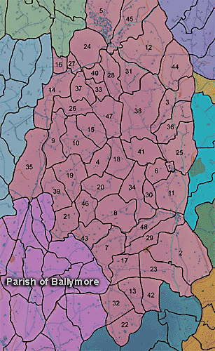
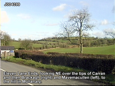
The townland of Mullanary is in the parish of Kilmore in Armagh County. It is labelled number 39 on the map.
Paterson (Armachiana, Vol. 16, p.245 notes:
...Mullan is the diminutive of Mullach ['top' or 'summit'] and is generally applied to a low and gently sloping hill.
The Environment and Heritage Service Sites and Monuments Record (2002) notes the following in this townland:
Rath from the Early Christian Period.
SMR NO: ARM 017:013
GRIDREF: J01543982
CONDITION: TRACES ONLY
"The 1835 OS 6" map shows a large circular ‘Fort’ c.50m in diam., but a rather smaller earthwork c.45m in diam. is indicated on the 1863 edition. Today, only a short length of the perimeter on the SW has survived. Here a substantial bank, c.4m wide still stands c.1.2m above the interior. From the top of the bank, there is a drop of c.3m to a waterlogged ditch, 4.5m across x 0.8m deep. Outside the ditch is a low bank, c.0.3m high which is probably upcast from recent recutting of the ditch."Rath from the Early Christian Period.
SMR NO: ARM 017:014
GRIDREF: J01474045
CONDITION: SOME REMAINS
"This large, roughly circular earthwork has been considerably eroded by cultivation and only a low platform 57m N-S x 61m E-W has survived. The perimeter around the NE is best preserved by incorporation in a field boundary & a bank c.3m wide x 1.4m high can be seen amidst the undergrowth. Around the N, the interior is level with the ground outside, but towards W & S it has been raised 0.6-1 m. Although this part of the site is poorly preserved, a slight scarp can be seen."Rath from the Early Christian Period.
SMR NO: ARM 017:015
GRIDREF: J01833996
CONDITION: TRACES ONLY
"A small circular earthwork, C.35m in diam. is marked on the 1863 OS 6" map & labelled "Fort" on the 1835 edition. The S & W sides have been disturbed by C19th building & a deserted settlement lies W. A field boundary crosses the N of the site ENE-WSW & N of this cultivation has removed almost all traces The arc of a shallow ditch C.10m wide x 0.6m deep survives S of the field boundary, disturbance & vegetation precluded examination. Field reports of 1960s state that the E part of the ditch was now a flax dam."Enclosure of uncertain period.
SMR NO: ARM 017:058
GRIDREF: J0140
NOT PRECISELY LOCATED
BIBLIOGRAPHY: - PATERSON,T.G.F. NOTES, VOL.135.
PRONI records: OS/6/2/10/1 (Surveyed 1834-35. Engraved 1835.); OS/6/2/10/2 ([Not received].); OS/6/2/10/3 (Surveyed 1834-35. Revised 1905. Published 1908.Reprinted 1931.); OS/6/2/10/4 (Surveyed 1905. Revised 1953 and 1955. Levelled 1889 to 1905 and 1948. Published 1959. (2 copies).); OS/6/2/14/1 (Surveyed 1834-35. Engraved 1835.); OS/6/2/14/2 (Surveyed 1834. Revised 1860. Engraved 1863 (Stat file copy).); OS/6/2/14/3 (Surveyed 1834-35. Revised 1906. Published 1908. Reprinted 1929. (2 copies).); OS/6/2/14/4 (Surveyed 1834-35. Revised 1906. Levelled 1905-06.Published 1908. Reprint 1951 and 1958.); OS/6/2/14/5 (Surveyed 1834. Revised 1860. Engraved 1863 (Stat file copy). Reprinted 1937 with mss markings in red and stamped ref 2569, 2570.); OS/6/2/14/6 (Surveyed 1906. Revised 1954. Levelled 1892, 1902 and 1904-06. Published 1958 (2 copies).); VAL/12B/11/4A, VAL/12B/11/14B, VAL/12B/11/14B, VAL/12B/11/4C, VAL/12B/11/4D, VAL/12B/11/4E, VAL/12B/11/4F (Valuation annual revision list.); VAL/2B/2/33 (Griffith valuation list.).
 J014405
