 H943429
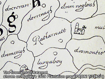
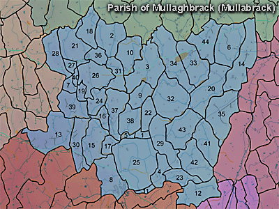
The townland of Ratarnet is in the parish of Mullaghbrack in Armagh County. It is labelled number 39 on the map.
The Environment and Heritage Service Sites and Monuments Record (2002) notes the following in this townland:
Rath from the Early Christian period
SMR NO: ARM 017:001
GRIDREF: H94054276:
CONDITION: TRACES ONLY
"A roughly circular platform in generally level pasture, approx. 37m diam. The N & W sides have been levelled so that only a slight scarp is visible. On the S & E the perimeter has been preserved by a curving field boundary. To the S are vestigal remains of an internal bank, spread c.2m wide and c.0.2m high. From the top of this low bank a steep scarp falls 1.7m to the base of a shallow ditch. This varies from 1-3m across & is c.0.Sm deep. It has been extensively recut for drainage."
PRONI records: OS/6/2/13/1 (Surveyed 1834-35. Engraved 1835.); OS/6/2/13/2 (Surveyed 1834-35. Revised 1860. Engraved 1863 (Stat file copy).); OS/6/2/13/3 (Surveyed 1834-35. Revised 1905-06. Published 1930.); OS/6/2/13/4 (Surveyed 1905-06. Revised 1954-55. Levelled 1888 and 1892 and 1902, 1905-1906. Levels part revised 1948. Published 1958. (2 copies).); OS/6/2/17/1 (Surveyed 1835. Engraved 1835.); OS/6/2/17/2 (Surveyed 1835. Engraved 1835. Revised 1860. Engraved 1863.); OS/6/2/17/3 (Surveyed 1835. Revised 1906. Published 1908. Reprinted 1929, 1932.); OS/6/2/17/4 (Surveyed 1906. Revised 1954-5. Levelled 1889, 1892 and 1906. Published 1958 (2 copies).); VAL/1B/213 (1st valuation records.); VAL/12B/10/24A, VAL/12B/10/24B, VAL/12B/10/24C, VAL/12B/10/24D (Valuation annual revision list.); VAL/2B/2/12B (Griffith valuation list.).
H943429