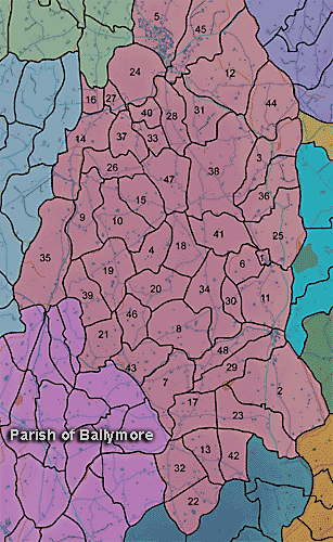
The townland of Terryhoogan is in the parish of Ballymore in Armagh County. It is labelled number 44 on the map.
PRONI records: OS/6/2/14/1 (Surveyed 1834-35. Engraved 1835.); OS/6/2/14/2 (Surveyed 1834. Revised 1860. Engraved 1863 (Stat file copy).); OS/6/2/14/3 (Surveyed 1834-35. Revised 1906. Published 1908. Reprinted 1929. (2 copies).); OS/6/2/14/4 (Surveyed 1834-35. Revised 1906. Levelled 1905-06.Published 1908. Reprint 1951 and 1958.); OS/6/2/14/5 (Surveyed 1834. Revised 1860. Engraved 1863 (Stat file copy). Reprinted 1937 with mss markings in red and stamped ref 2569, 2570.); OS/6/2/14/6 (Surveyed 1906. Revised 1954. Levelled 1892, 1902 and 1904-06. Published 1958 (2 copies).); D.1905/2 (Map by Thomas Gribbin; part of estate of Edward Lucas Esq.); VAL/1B/214 (1st valuation records.); VAL/12B/11/5B, VAL/12B/11/5C, VAL/12B/11/5D, VAL/12B/11/5E (Valuation annual revision list.); VAL/2B/2/32BC 1863 (Griffith valuation list.C 1863); D/1905/2 (Map, part of the estate of Edward Lucas, Esq., surveyed June 1769 by Thomas Gribbin.).
